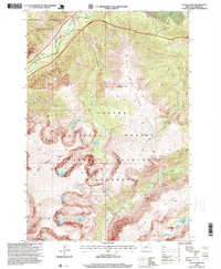
1996 Map of Sylvan Peak
USGS Topo · Published 1999About this map
The Absaroka Beartooth Wilderness dominates this landscape, defined by high-elevation landforms like the Rosebud Plateau and Sylvan Plateau. This 1990s-era study captures the high country of Custer National Forest, where steep drainage systems like Hellroaring Creek and Red Lodge Creek feed into glacial lakes. Notable peaks such as Sylvan Peak and Bowback Mountain tower over alpine basins, while lower elevations feature open spaces like Quinnpebaugh Meadows. The transition from the rugged crests to the valley floors is marked by water features including Calamity Falls and Sentinel Falls along West Fork Rock Creek. The presence of the Jimmy Joe site and various mountain landmarks such as Three Sisters provides specific points of interest for those studying the remote topography of the Carbon County region.
Find a feature on this map
34 named features on this map. Tap any name to fly to it.
Don’t see what you’re looking for? This feature index may not catch every label — zoom into the map to look around manually.
Map Details
Editions of this 1996 Sylvan Peak Map
This is the sole edition of this map. No revisions or reprints were ever made.
Other maps of this area

1898 · Granite Mountain District
USGS Topo · 1:125,000

1932 · Red Lodge No 2
USGS Topo · 1:48,000

1932 · Nye No 1
USGS Topo · 1:48,000

1954 · Billings
USGS Topo · 1:250,000
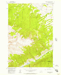
1956 · Emerald Lake
USGS Topo · 1:24,000

1956 · Roscoe
USGS Topo · 1:24,000

1956 · Alpine
USGS Topo · 1:62,500

1956 · Mackay Ranch
USGS Topo · 1:24,000

1956 · Mount Maurice
USGS Topo · 1:62,500

1957 · Billings
USGS Topo · 1:250,000