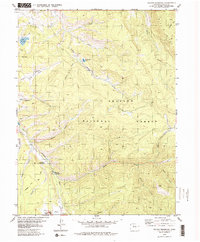
1979 Map of Sylvan Reservoir
USGS Topo · Published 1979About this map
Arapaho National Forest dominates this landscape, showing a complex network of drainages and high-elevation parks in the late 1970s. The hydrology of the area is defined by the convergence of numerous named streams, including Little Muddy Creek, Kelly Creek, and Keyser Creek, which carve through deep gulches like Sylvan Gulch and Morgan Gulch. Human infrastructure is sparse but significant, centered on water management and forest service operations. The Sylvan Reservoir and De Koevend Lake appear as key water bodies, while the Horseshoe Guard Station provides a central landmark for wilderness management. Evident industrial activity is concentrated near Ute Park in the south, where Gravel Pits and a Tailings Pond indicate the localized extraction and processing of materials. Higher elevations are marked by the prominent Blue Ridge and the open spaces of Brinker Park.
Find a feature on this map
29 named features on this map. Tap any name to fly to it.
Don’t see what you’re looking for? This feature index may not catch every label — zoom into the map to look around manually.
Map Details
Editions of this 1979 Sylvan Reservoir Map
3 editions found
Other maps of this area

1915 · Longs Peak
USGS Topo · 1:125,000

1919 · Rocky Mountain National Park
USGS Topo · 1:125,000

1924 · Fraser
USGS Topo · 1:62,500

1926 · Fraser
USGS Topo · 1:62,500

1933 · Ute Peak
USGS Topo · 1:62,500

1937 · Ute Peak
USGS Topo · 1:62,500

1953 · Denver
USGS Topo · 1:250,000

1954 · Greeley
USGS Topo · 1:250,000

1954 · Craig
USGS Topo · 1:250,000

1957 · Denver
USGS Topo · 1:250,000