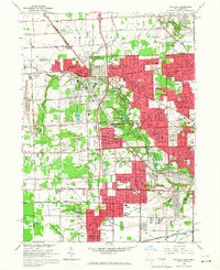
1965 Map of Sylvania
USGS Topo · Published 1967About this map
The Michigan Ohio border defines the northern edge of this 1965 survey, where the expanding suburbs of Toledo meet the established community of Sylvania. The landscape is a mix of dense residential development and institutional grounds, notably the large Toledo Memorial Park and the sprawling Camp Miakonda along the Ottawa River. The industrial presence is marked by a Quarry near the small settlement of Silica to the west, while the New York Central Railroad corridor cuts diagonally through the terrain, anchoring the local transportation network alongside major thoroughfares like Central Ave and Alexis Rd.
Find a feature on this map
51 named features on this map. Tap any name to fly to it.
Don’t see what you’re looking for? This feature index may not catch every label — zoom into the map to look around manually.
Map Details
Editions of this 1965 Sylvania Map
Other maps of this area

1900 · Toledo
USGS Topo · 1:62,500

1911 · Swanton
USGS Topo · 1:62,500

1912 · Dundee
USGS Topo · 1:62,500

1914 · Swanton
USGS Topo · 1:62,500

1926 · Dundee
USGS Topo · 1:62,500

1934 · Rossford
USGS Topo · 1:24,000

1935 · Whitehouse
USGS Topo · 1:24,000

1935 · Maumee
USGS Topo · 1:24,000

1935 · Berkey
USGS Topo · 1:24,000

1936 · Samaria
USGS Topo · 1:31,680