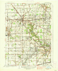
1937 Map of Sylvania
USGS Topo · Published 1937About this map
The New York Central Railroad and several electric or freight lines, such as the Toledo and Western Railroad, anchor this 1930s landscape along the Michigan-Ohio border. Sylvania serves as the primary hub, surrounded by a transition from industrial activity to suburban development. To the west, the Medusa Quarry and France Quarry near Silica highlight the region's extraction history. Moving toward the burgeoning residential areas to the east, the map reveals leisure and community landmarks like the Ottawa Hills Riding Club, Highland Meadows Golf Club, and a Boy Scout Reservation along Tenmile Creek. The southern portion of the map is defined by the North Boundary Twelvemile Reservation, showing a dense network of local drainage such as Hill Ditch and Zink Ditch that shaped the agricultural and residential plats of Springfield and Adams townships.
Find a feature on this map
100 named features on this map. Tap any name to fly to it.
Don’t see what you’re looking for? This feature index may not catch every label — zoom into the map to look around manually.
Map Details
Editions of this 1937 Sylvania Map
2 editions found
Other maps of this area

1900 · Toledo
USGS Topo · 1:62,500

1911 · Swanton
USGS Topo · 1:62,500

1912 · Dundee
USGS Topo · 1:62,500

1914 · Swanton
USGS Topo · 1:62,500

1926 · Dundee
USGS Topo · 1:62,500

1934 · Rossford
USGS Topo · 1:24,000

1935 · Whitehouse
USGS Topo · 1:24,000

1935 · Maumee
USGS Topo · 1:24,000

1935 · Berkey
USGS Topo · 1:24,000

1936 · Samaria
USGS Topo · 1:31,680