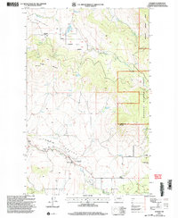
2001 Map of Synarep
USGS Topo · Published 2004About this map
Tunk Valley Creek winds through this Okanogan County landscape, providing a geographic anchor for the small settlement of Synarep and the nearby Tunk Valley Cemetery. The map reflects a rural community structured around small schools and high-elevation ranching, with the Chewiliken School to the north and the Howe School to the south. An Indian Allotment Boundary is clearly delineated near Talkire Lake, marking the historical intersection of tribal land management and the Okanogan National Forest.
Find a feature on this map
22 named features on this map. Tap any name to fly to it.
Don’t see what you’re looking for? This feature index may not catch every label — zoom into the map to look around manually.
Map Details
Editions of this 2001 Synarep Map
This is the sole edition of this map. No revisions or reprints were ever made.
Other maps of this area

1902 · Osoyoos
USGS Topo · 1:125,000

1904 · Osoyoos
USGS Topo · 1:125,000

1952 · Disautel
USGS Topo · 1:62,500

1953 · Omak Lake
USGS Topo · 1:62,500

1954 · Okanogan
USGS Topo · 1:250,000

1957 · Tonasket
USGS Topo · 1:62,500

1957 · Aeneas Valley
USGS Topo · 1:62,500

1958 · Okanogan
USGS Topo · 1:250,000
1980 · Keystone
USGS Topo · 1:24,000
1980 · The Pothole
USGS Topo · 1:24,000