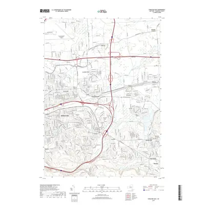
2019 Map of Syracuse East
USGS Topo · Published 2019About this map
Syracuse and its eastern suburbs form a dense network of residential and commercial development, bound by the heavy infrastructure of the CSX railroad and major highway interchanges. The landscape is dotted with significant institutional and memorial sites, from the campus of Le Moyne College to several large burial grounds such as White Chapel Memory Gardens and the Dewitt Cemetery Old Section. To the north, the Syracuse Hancock International Airport occupies a large footprint, while the village of Fayetteville anchors the southeastern corner near the Fayetteville Pioneer Burial Ground. Watercourses like Butternut Creek and Ley Cr thread through the suburban expansion, providing natural breaks between neighborhoods like East Syracuse, Franklin Park, and Minoa. The map also captures local landmarks such as Ratnour Bridge and the elevated terrain of Clark Hill, illustrating the transition from urban center to established satellite communities.
Find a feature on this map
72 named features on this map. Tap any name to fly to it.
Don’t see what you’re looking for? This feature index may not catch every label — zoom into the map to look around manually.
Map Details
Editions of this 2019 Syracuse East Map
This is the sole edition of this map. No revisions or reprints were ever made.
Other maps of this area

1895 · Chittenango
USGS Topo · 1:62,500

1895 · Syracuse
USGS Topo · 1:62,500

1897 · Cazenovia
USGS Topo · 1:62,500

1898 · Syracuse
USGS Topo · 1:62,500

1898 · Chittenango
USGS Topo · 1:62,500

1899 · Cazenovia
USGS Topo · 1:62,500

1900 · Tully
USGS Topo · 1:62,500

1902 · Chittenango
USGS Topo · 1:62,500

1938 · Syracuse East
USGS Topo · 1:24,000

1939 · Syracuse West
USGS Topo · 1:24,000