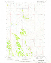
1973 Map of T Creek
USGS Topo · Published 1976About this map
Moonlight Creek and its numerous seasonal tributaries carve a complex drainage pattern across this section of Powder River County. The landscape is defined by the winding paths of Mizpah Creek, Flat Creek, and Lake Creek, which converge in a region where water management and cattle ranching have long shaped the land. The presence of Twin Buttes provides a prominent natural landmark amidst the relief, while several Drill Holes and scattered Gravel Pits indicate the subsurface exploration and local resource extraction common in this part of Montana during the early 1970s.
Find a feature on this map
14 named features on this map. Tap any name to fly to it.
Don’t see what you’re looking for? This feature index may not catch every label — zoom into the map to look around manually.
Map Details
Editions of this 1973 T Creek Map
3 editions found
Other maps of this area

1954 · Ekalaka
USGS Topo · 1:250,000

1956 · Ekalaka
USGS Topo · 1:250,000

1958 · Ekalaka
USGS Topo · 1:250,000

1965 · Ekalaka
USGS Topo · 1:250,000

1973 · Olive
USGS Topo · 1:24,000

1973 · Cross S School
USGS Topo · 1:24,000

1973 · Monday Creek
USGS Topo · 1:24,000

1973 · Moonlight Creek
USGS Topo · 1:24,000

1973 · Coalwood
USGS Topo · 1:24,000

1973 · Hawkey Creek
USGS Topo · 1:24,000