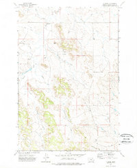
1973 Map of T Creek
USGS Topo · Published 1976About this map
Twin Buttes rises as a prominent landmark amidst a branching network of drainages in this section of Powder River County. The landscape is defined by the winding course of Mizpah Creek and its many tributaries, including Double Corral Creek and Moonlight Creek. The density of named watercourses such as Hudson Creek, Dry Creek, and Charles Creek highlights the complex topography of the Montana rangeland during the early 1970s. Industrial activity is sparsely represented but present through features like a Gravel Pit and several drill holes, indicating local resource extraction or exploration. The southern portion of the map is shaped by the presence of Government Creek and T A Creek, illustrating the remote and rugged character of the terrain before later modern developments. This survey provides a clear view of the land as it was mapped by the Geological Survey using photogrammetric methods.
Find a feature on this map
13 named features on this map. Tap any name to fly to it.
Don’t see what you’re looking for? This feature index may not catch every label — zoom into the map to look around manually.
Map Details
Editions of this 1973 T Creek Map
3 editions found
Other maps of this area

1954 · Ekalaka
USGS Topo · 1:250,000

1956 · Ekalaka
USGS Topo · 1:250,000

1958 · Ekalaka
USGS Topo · 1:250,000

1965 · Ekalaka
USGS Topo · 1:250,000

1973 · Olive
USGS Topo · 1:24,000

1973 · Cross S School
USGS Topo · 1:24,000

1973 · Monday Creek
USGS Topo · 1:24,000

1973 · Moonlight Creek
USGS Topo · 1:24,000

1973 · Coalwood
USGS Topo · 1:24,000

1973 · Hawkey Creek
USGS Topo · 1:24,000