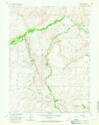
1958 Map of T L Ranch
USGS Topo · Published 1967About this map
The Medicine Bow River carves a fertile path through the high plains of Carbon County in this late-1950s survey. The landscape is defined by the legacy of Western ranching and overland transport, featuring a network of family-held operations like the T L Ranch and Orton Ranch. Evidence of earlier settlement remains in the form of abandoned sites such as the Old Brooks Place and Tyler Homestead, which sit near the historic route of the Overland Trail. This trail, a vital artery for 19th-century pioneers, is traced as it crosses the central flats and ridges. Industrial activity is concentrated in the northern hills at the Black Diamond Mines and Kem Mine, while the southern reaches near Sheepherder Hill show the influence of modern infrastructure with oil infrastructure and the presence of a Historical Monument along the Wagonhound Creek drainage.
Find a feature on this map
35 named features on this map. Tap any name to fly to it.
Don’t see what you’re looking for? This feature index may not catch every label — zoom into the map to look around manually.
Map Details
Editions of this 1958 T L Ranch Map
3 editions found

Other maps of this area

1914 · Saddleback Hills
USGS Topo · 1:62,500

1915 · Como Ridge
USGS Topo · 1:48,000

1918 · Como Ridge
USGS Topo · 1:62,500

1921 · Saddleback Hills
USGS Topo · 1:62,500

1954 · Rawlins
USGS Topo · 1:250,000

1955 · Elk Mountain
USGS Topo · 1:24,000

1955 · Elk Mountain SW
USGS Topo · 1:24,000

1958 · Rawlins
USGS Topo · 1:250,000

1958 · White Rock Canyon
USGS Topo · 1:24,000

1958 · Arlington
USGS Topo · 1:24,000