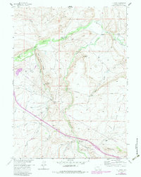
1958 Map of T L Ranch
USGS Topo · Published 1983About this map
Medicine Bow River winds through this Carbon County landscape, anchoring a network of high-plains ranches and early industrial sites. The map documents a classic Wyoming ranching economy during the mid-20th century, with established operations like the T L Ranch and Johnson Ranch situated along the river and its tributaries. To the north, the presence of the Black Diamond Mines and Kent Mine highlights the region's coal extraction history, while a cluster of Oil Wells and oil tanks indicates the 1950s energy expansion.
Find a feature on this map
38 named features on this map. Tap any name to fly to it.
Don’t see what you’re looking for? This feature index may not catch every label — zoom into the map to look around manually.
Map Details
Editions of this 1958 T L Ranch Map
3 editions found

Other maps of this area

1914 · Saddleback Hills
USGS Topo · 1:62,500

1915 · Como Ridge
USGS Topo · 1:48,000

1918 · Como Ridge
USGS Topo · 1:62,500

1921 · Saddleback Hills
USGS Topo · 1:62,500

1954 · Rawlins
USGS Topo · 1:250,000

1955 · Elk Mountain
USGS Topo · 1:24,000

1955 · Elk Mountain SW
USGS Topo · 1:24,000

1958 · Rawlins
USGS Topo · 1:250,000

1958 · White Rock Canyon
USGS Topo · 1:24,000

1958 · Arlington
USGS Topo · 1:24,000