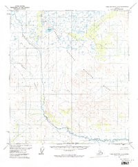
1972 Map of Table Mountain A-5
USGS Topo · Published 1974About this map
Arctic National Wildlife Range defines the vast majority of this 1972 topography, documenting a landscape shaped by glacial and periglacial processes in northern Alaska. The northern portion of the quadrangle is characterized by a high concentration of small thermokarst ponds and lakes, the largest being Sheenjek Lake. To the south, the terrain transitions into more pronounced relief where Monument Creek carves through the mountains. This survey, compiled from aerial photography, captures the intricate hydrological patterns of the region before any significant human development, showing the drainage systems that feed into the larger river valleys of the Brooks Range foothills. The map provides a detailed view of the natural contours and swampy lowlands that dictated movement through this subarctic wilderness during the early 1970s.
Find a feature on this map
4 named features on this map. Tap any name to fly to it.
Don’t see what you’re looking for? This feature index may not catch every label — zoom into the map to look around manually.
Map Details
Editions of this 1972 Table Mountain A-5 Map
This is the sole edition of this map. No revisions or reprints were ever made.
Other maps of this area

1951 · Coleen
USGS Topo · 1:250,000

1951 · Christian
USGS Topo · 1:250,000

1951 · Arctic
USGS Topo · 1:250,000

1951 · Table Mountain
USGS Topo · 1:250,000

1956 · Table Mountain
USGS Topo · 1:250,000

1956 · Coleen
USGS Topo · 1:250,000

1956 · Arctic
USGS Topo · 1:250,000

1956 · Christian
USGS Topo · 1:250,000

1964 · Table Mountain
USGS Topo · 1:250,000
1972 · Arctic A-1
USGS Topo · 1:63,360