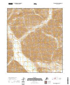
2018 Map of Table Mountain D-5 NE
USGS Topo · Published 2018About this map
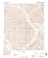
The Sheenjek River defines this landscape in the eastern Brooks Range, winding through a series of valleys as it flows southward toward the Yukon basin. This 2018 survey documents a region of the North Slope Borough characterized by dramatic elevation changes and a complete absence of modern infrastructure or permanent settlements. The map highlights the vast scale of the Public Land Survey System, illustrating the boundaries of several townships including T5s R36e and T6s R36e. Geologists and researchers can trace the intricate drainage patterns of the river and its unnamed tributaries, which carve through the high terrain to create a complex network of ridgelines and basins. The lack of roads or structures emphasizes the remote nature of this portion of the Alaskan interior at the time of the imagery.
Find a feature on this map
7 named features on this map. Tap any name to fly to it.
Don’t see what you’re looking for? This feature index may not catch every label — zoom into the map to look around manually.
Map Details
Editions of this 2018 Table Mountain D-5 NE Map
This is the sole edition of this map. No revisions or reprints were ever made.
Other maps of this area

1951 · Demarcation Point
USGS Topo · 1:250,000

1951 · Table Mountain
USGS Topo · 1:250,000

1955 · Demarcation Point
USGS Topo · 1:250,000

1956 · Table Mountain
USGS Topo · 1:250,000

1964 · Table Mountain
USGS Topo · 1:250,000

1964 · Demarcation Point
USGS Topo · 1:250,000
1983 · Table Mountain D-4
USGS Topo · 1:63,360
1983 · Demarcation Point A-5
USGS Topo · 1:63,360
1983 · Demarcation Point A-4
USGS Topo · 1:63,360
1983 · Table Mountain D-5
USGS Topo · 1:63,360