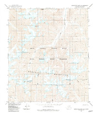
1983 Map of Demarcation Point A-5
USGS Topo · Published 1983About this map
Mount Isto stands as the prominent landmark within the Romanzof Mountains, anchor of this high-latitude terrain. This 1983 edition, based on earlier photogrammetric surveys, documents the glacial extent of the Arey Glacier and Schwanda Glacier before modern shifts in ice coverage. The landscape is defined by the Continental Divide, which separates the north-flowing headwaters of the Jago River and Aichilik River from the drainage of the Sheenjek River to the south. Located entirely within the Arctic National Wildlife Refuge, the area highlights a wilderness state where no roads or trails were recorded, reflecting the topographical complexity of the eastern Brooks Range during the late twentieth century.
Find a feature on this map
10 named features on this map. Tap any name to fly to it.
Don’t see what you’re looking for? This feature index may not catch every label — zoom into the map to look around manually.
Map Details
Editions of this 1983 Demarcation Point A-5 Map
This is the sole edition of this map. No revisions or reprints were ever made.
Other maps of this area

1951 · Demarcation Point
USGS Topo · 1:250,000

1951 · Arctic
USGS Topo · 1:250,000

1951 · Table Mountain
USGS Topo · 1:250,000

1951 · Mt. Michelson
USGS Topo · 1:250,000

1955 · Demarcation Point
USGS Topo · 1:250,000

1955 · Mount Michelson B-1
USGS Topo · 1:63,360

1956 · Table Mountain
USGS Topo · 1:250,000

1956 · Arctic
USGS Topo · 1:250,000

1956 · Mt. Michelson
USGS Topo · 1:250,000
1956 · Demarcation Point B-4
USGS Topo · 1:63,360