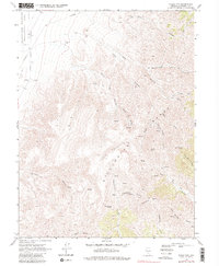
1969 Map of Table Mtn
USGS Topo · Published 1982About this map
Stillwater Mountain and the high ridges of the Stillwater Range dominate this 1960s landscape, where a network of trails and jeep tracks connects remote water sources and peaks. The presence of West Lee Well and named springs like Hard Time Spring underscores the importance of reliable water in this arid Churchill County environment. A transition in land use is evident along the western edge, where the Stillwater Wildlife Management Area meets the high desert floor. Resource extraction is hinted at by the Borrow Pits near the northern border, while the complex drainage system of Shirt-tail Canyon, Huckleberry Canyon, and Quaking Aspen Canyon defines the rugged eastern slopes. High points such as Mount Lincoln and Shaly Peak provide significant navigational landmarks across the interior.
Find a feature on this map
32 named features on this map. Tap any name to fly to it.
Don’t see what you’re looking for? This feature index may not catch every label — zoom into the map to look around manually.
Map Details
Editions of this 1969 Table Mtn Map
3 editions found
Other maps of this area

1908 · Carson Sink
USGS Topo · 1:250,000

1910 · Carson Sink
USGS Topo · 1:250,000

1957 · Reno
USGS Topo · 1:250,000

1959 · Reno
USGS Topo · 1:250,000

1960 · Reno
USGS Topo · 1:250,000

1969 · Cox Canyon
USGS Topo · 1:24,000

1969 · Table Mtn
USGS Topo · 1:24,000

1969 · Pintail Bay
USGS Topo · 1:24,000

1969 · Foxtail Lake
USGS Topo · 1:24,000

1972 · Pirouette Mtn
USGS Topo · 1:24,000