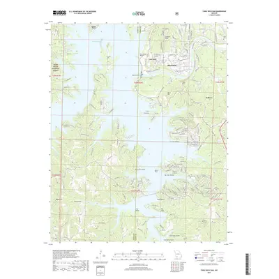
2017 Map of Table Rock Dam
USGS Topo · Published 2017About this map
Table Rock Dam stands as the central engineering feat of this White River landscape, separating the deep waters of Table Rock Lake from Lake Taneycomo to the east. This modern survey illustrates the complex interface between the developed tourist corridor of Branson and Hollister and the surrounding Ozark woodlands of the Mark Twain National Forest. The map captures a high degree of contemporary development along the lakefronts, contrasted with the steep, timbered relief of Baird Mtn and Compton Ridge. Genealogists and local researchers will find several well-preserved family and community landmarks, including Goodall Cem and Bowman Cem, situated amidst numerous named geographic features like Persimmon Hollow and Oasis Bluff. This era shows the region as a major recreation and utility hub, with a dense network of secondary roads such as State Hwy JJ and State Hwy EE providing access to the winding shoreline.
Find a feature on this map
180 named features on this map. Tap any name to fly to it.
Don’t see what you’re looking for? This feature index may not catch every label — zoom into the map to look around manually.
Map Details
Editions of this 2017 Table Rock Dam Map
This is the sole edition of this map. No revisions or reprints were ever made.
Other maps of this area

1904 · Harrison
USGS Topo · 1:125,000

1905 · Harrison
USGS Topo · 1:125,000

1907 · Forsyth
USGS Topo · 1:125,000

1945 · Harrison
USGS Topo · 1:250,000

1949 · Harrison
USGS Topo · 1:250,000

1950 · Garber
USGS Topo · 1:24,000

1954 · Harrison
USGS Topo · 1:250,000

1956 · Lampe
USGS Topo · 1:24,000

1956 · Table Rock Dam
USGS Topo · 1:24,000

1956 · Garber
USGS Topo · 1:24,000