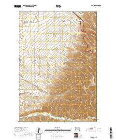
2020 Map of Table Rock
USGS Topo · Published 2020About this map
Tutuilla sits at the northern edge of this Umatilla County landscape, where the flat agricultural plains of the Umatilla Indian Reservation begin their ascent into the folded canyons of the Blue Mountains. The terrain is defined by a series of deep drainages, including North Coyote Canyon, South Coyote Canyon, and McDonald Canyon, which carve through the high ground leading toward the prominent Table Rock. These canyons direct seasonal water through creeks such as N Coyote Cr and Tutuilla Cr, eventually feeding the larger McKay Cr system to the south.
Find a feature on this map
46 named features on this map. Tap any name to fly to it.
Don’t see what you’re looking for? This feature index may not catch every label — zoom into the map to look around manually.
Map Details
Editions of this 2020 Table Rock Map
This is the sole edition of this map. No revisions or reprints were ever made.
Other maps of this area

1935 · Pendleton
USGS Topo · 1:125,000

1953 · Pendleton
USGS Topo · 1:250,000

1956 · Pendleton
USGS Topo · 1:250,000

1966 · Cabbage Hill
USGS Topo · 1:24,000

1966 · Mc Kay Reservoir
USGS Topo · 1:24,000
1966 · Cayuse
USGS Topo · 1:24,000

1966 · Table Rock
USGS Topo · 1:24,000

1966 · Pendleton
USGS Topo · 1:24,000

1966 · Mission
USGS Topo · 1:24,000
1967 · Bassey Creek
USGS Topo · 1:24,000