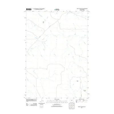
2012 Map of Table Top Butte
USGS Topo · Published 2012About this map
Table Top Butte rises above the drainage of S Sulphur Cr in this high-plains landscape of western South Dakota. The terrain is defined by prominent topographical markers like Saddle Butte and Rattlesnake Butte, which likely served as essential landmarks for early travelers and cattle drivers. The sparse infrastructure consists primarily of local routes such as Killdeer Rd and Longhorn Pl, reflecting the enduring rural character of this Meade County region. The winding path of Soft Water Cr and the presence of Old Hwy 212 suggest a land managed for grazing and long-distance travel, where natural water sources and reliable roads dictate the layout of human activity. This U.S. Geological Survey record captures the relationship between the elevated buttes and the seasonal creek beds that dominate the local environment.
Find a feature on this map
8 named features on this map. Tap any name to fly to it.
Don’t see what you’re looking for? This feature index may not catch every label — zoom into the map to look around manually.
Map Details
Editions of this 2012 Table Top Butte Map
This is the sole edition of this map. No revisions or reprints were ever made.
Other maps of this area

1913 · Newell
USGS Topo · 1:125,000

1953 · Rapid City
USGS Topo · 1:250,000

1957 · Rapid City
USGS Topo · 1:250,000

1959 · Fairpoint
USGS Topo · 1:24,000
1959 · Volunteer NE
USGS Topo · 1:24,000

1959 · Fairpoint NW
USGS Topo · 1:24,000

1973 · Frozen Man Creek
USGS Topo · 1:24,000

1977 · Table Top Butte
USGS Topo · 1:24,000
1977 · Owl Butte SE
USGS Topo · 1:24,000
1978 · Owl Butte NE
USGS Topo · 1:24,000