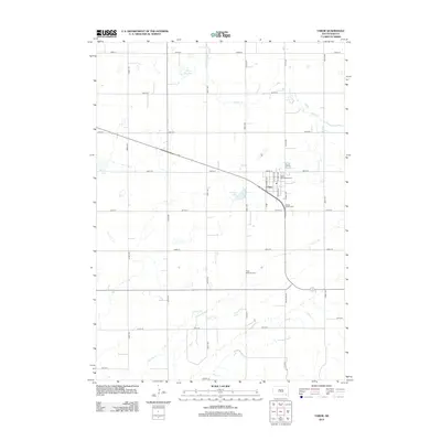
2012 Map of Tabor
USGS Topo · Published 2012About this map
Tabor serves as the central hub of this agricultural landscape in Bon Homme County, where the street grid honors heritage with names like N Janda Ave, N Lidice Ave, and Zizkov St. The area's settlement history is deeply rooted in its local institutions, evidenced by the presence of Saint Wenceslaus Cem and Hvezda Zapadu Cem on the outskirts of the town. Outside the residential center, the terrain is defined by a series of prairie lakes, including Hruska Lake, Pechous Lake, and Kubal Lake, which dot the plains alongside the meandering paths of Beaver Cr and Charley Cr. This 2012 survey illustrates a well-organized rural infrastructure where a strict grid of section roads like 307th St and 425th Ave connects family-named landmarks and local burial grounds such as Ptaks National Cem.
Find a feature on this map
31 named features on this map. Tap any name to fly to it.
Don’t see what you’re looking for? This feature index may not catch every label — zoom into the map to look around manually.
Map Details
Editions of this 2012 Tabor Map
This is the sole edition of this map. No revisions or reprints were ever made.
Other maps of this area

1898 · Olivet
USGS Topo · 1:125,000

1955 · Sioux City
USGS Topo · 1:250,000

1955 · Sioux Falls
USGS Topo · 1:250,000

1958 · Sioux City
USGS Topo · 1:250,000

1958 · Sioux Falls
USGS Topo · 1:250,000

1959 · Sioux City
USGS Topo · 1:250,000

1968 · Tabor SE
USGS Topo · 1:24,000

1974 · Bon Homme Colony
USGS Topo · 1:24,000

1978 · Tripp SE
USGS Topo · 1:24,000
1978 · Santee
USGS Topo · 1:24,000
Featured Places
- Tabor, SD
- Ziskov South Township, SD
- Little Tabor Township, SD
- Lesterville Township, SD
- Ziskov North Township, SD