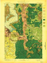
1897 Map of Tacoma
USGS Topo · Published 1897About this map
Puyallup Indian Reservation and the Muckleshoot Indian Reservation anchor the central landscape of this late-nineteenth-century timber and land classification study. Surveyed by Henry Gannett, the data reveals a region in the midst of heavy industrial transformation, distinguishing between merchantable forests and areas already cut or burned. Coastal settlements like Des Moines and Adelaide sit along the eastern shore of Puget Sound Admiralty Inlet, while inland, the rail-driven economy is evident in the coal-mining corridors near Black Diamond, Wilkeson, and Carbonado. The transit network of the Northern Pacific Railroad connects the bustling port of Tacoma to smaller agricultural and timber outposts such as Kent, O'Brien, and Maple Valley. The map also captures the intricate geography of the islands, including Vashon Island and Maury Island, separated by Quartermaster Harbor, before the heavy urbanization of the Puget Sound region.
Find a feature on this map
134 named features on this map. Tap any name to fly to it.
Don’t see what you’re looking for? This feature index may not catch every label — zoom into the map to look around manually.
Map Details
Editions of this 1897 Tacoma Map
2 editions found
Other maps of this area

1894 · Seattle
USGS Topo · 1:62,500

1895 · Snohomish
USGS Topo · 1:125,000

1897 · Tacoma
USGS Topo · 1:125,000

1897 · Seattle
USGS Topo · 1:125,000

1900 · Tacoma
USGS Topo · 1:125,000

1908 · Seattle
USGS Topo · 1:62,500

1909 · Seattle Special
USGS Topo · 1:62,500

1913 · Cedar Lake
USGS Topo · 1:125,000

1916 · Chehalis
USGS Topo · 1:125,000

1921 · Sultan
USGS Topo · 1:125,000