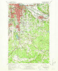
1961 Map of Tacoma South
USGS Topo · Published 1968About this map
Tacoma and its southern suburbs appear in this 1961 record of industrial and military expansion in Pierce County. The landscape is dominated by the vast grounds of Fort Lewis Military Reservation and Mc Chord Air Force Base, while the Puyallup River valley serves as a corridor for the Northern Pacific, Union Pacific, and Great Northern railroads. The map highlights the educational and cultural infrastructure of the mid-century, from the campus of Pacific Lutheran University in Parkland to the Mary Mount Military Academy. Settlement patterns follow the Pacific Highway corridor, connecting the northern urban center to rural communities like Elk Plain and Graham. The survey also details community spaces such as Cheney Stadium, the Fairgrounds in Puyallup, and several small family burial sites including Henry Smith Cem and Jeschke Cem, providing a deep look at the local geography before suburban infill reached these outer reaches.
Find a feature on this map
124 named features on this map. Tap any name to fly to it.
Don’t see what you’re looking for? This feature index may not catch every label — zoom into the map to look around manually.
Map Details
Editions of this 1961 Tacoma South Map
This is the sole edition of this map. No revisions or reprints were ever made.
Other maps of this area

1897 · Tacoma
USGS Topo · 1:125,000

1900 · Tacoma
USGS Topo · 1:125,000

1916 · Chehalis
USGS Topo · 1:125,000

1937 · Eatonville
USGS Topo · 1:125,000

1940 · Anderson Island
USGS Topo · 1:62,500

1941 · Tanwax Lake
USGS Topo · 1:62,500

1941 · Tacoma South
USGS Topo · 1:62,500

1942 · Gig Harbor
USGS Topo · 1:62,500

1942 · Lake Tapps
USGS Topo · 1:62,500

1943 · Gig Harbor
USGS Topo · 1:62,500