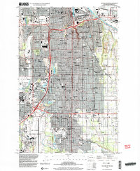
1997 Map of Tacoma South
USGS Topo · Published 2003About this map
Tacoma and its southern suburbs are captured here at a moment of significant infrastructure development, where established neighborhoods like Oakland and Salishan meet the industrial corridors of the Puyallup River. The map illustrates a landscape of institutional history, from the prominent campus of Pacific Lutheran University in Parkland to the vast footprint of Mc Chord Air Force Base dominating the southwestern corner. These hubs of education and defense are interspersed with historic local anchors like Tacoma Cemetery and Lincoln High Sch.
Find a feature on this map
97 named features on this map. Tap any name to fly to it.
Don’t see what you’re looking for? This feature index may not catch every label — zoom into the map to look around manually.
Map Details
Editions of this 1997 Tacoma South Map
This is the sole edition of this map. No revisions or reprints were ever made.
Other maps of this area

1897 · Tacoma
USGS Topo · 1:125,000

1900 · Tacoma
USGS Topo · 1:125,000

1940 · Anderson Island
USGS Topo · 1:62,500

1941 · Tacoma South
USGS Topo · 1:62,500

1942 · Gig Harbor
USGS Topo · 1:62,500

1943 · Gig Harbor
USGS Topo · 1:62,500

1944 · Tacoma South
USGS Topo · 1:62,500

1948 · Anderson Island
USGS Topo · 1:62,500

1948 · Fort Lewis
USGS Topo · 1:24,000

1948 · Steilacoom
USGS Topo · 1:24,000