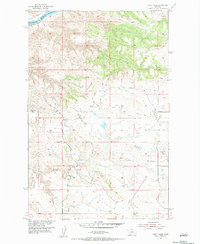
1954 Map of Taffy Ridge
USGS Topo · Published 1984About this map
The Missouri River cuts through the northern reaches of this territory, where the Dauphin Rapids create a break in the water flow at the border between Blaine and Fergus counties. This mid-century survey, produced for the Missouri River Basin development program, shows a landscape defined by prominent ridgelines and seasonal drainages. Whiskey Ridge dominates the west, while Taffy Ridge and Cutbank Ridge stretch across the central and southern portions of the quadrangle. Evidence of early extractive industry is present in the form of a Coal Mine (Inactive) located in the southern sections near Taffy Creek. The drainage patterns of Dog Creek and Cutbank Creek further illustrate the complex erosion and topographical relief characteristic of this part of central Montana.
Find a feature on this map
10 named features on this map. Tap any name to fly to it.
Don’t see what you’re looking for? This feature index may not catch every label — zoom into the map to look around manually.
Map Details
Editions of this 1954 Taffy Ridge Map
2 editions found
Other maps of this area

1954 · Taffy Ridge
USGS Topo · 1:24,000

1954 · Bird Rapids
USGS Topo · 1:24,000

1954 · Leroy
USGS Topo · 1:24,000

1954 · Gallatin Rapids
USGS Topo · 1:24,000

1954 · Lewistown
USGS Topo · 1:250,000

1959 · Lewistown
USGS Topo · 1:250,000

1964 · Ragland Bench
USGS Topo · 1:24,000

1985 · Woodhawk Hill
USGS Topo · 1:24,000
1985 · Gerhard Corner
USGS Topo · 1:24,000
1985 · Winifred East
USGS Topo · 1:24,000