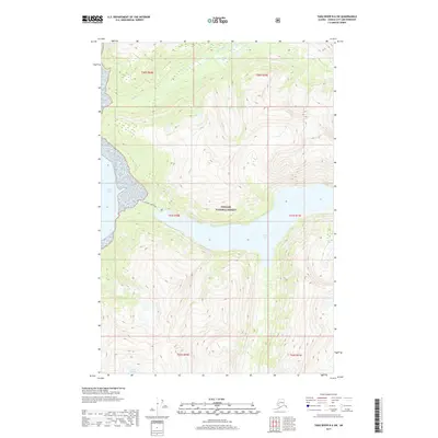
2017 Map of Taku River B-6 SW
USGS Topo · Published 2017About this map
Tongass National Forest dominates the landscape of this coastal Alaskan region, where steep elevations drop sharply toward the tidal waters of Taku Inlet. The topography is defined by the significant glacially-carved basin of Turner Lake, which sits tucked between high ridges in the central portion of the map. Access to this wilderness is noted by the W Turner Lake Trail, a rare piece of terrestrial infrastructure in an area otherwise governed by waterways and high-relief terrain. To the north, Davidson Cr drains through the steep valleys, while Lake Dorothy occupies the southwestern corner, reflecting the high-altitude freshwater systems characteristic of the Juneau City and Borough periphery. The map effectively illustrates the transition from the marine environment of the inlet to the interior freshwater lakes and the surrounding national forest lands.
Find a feature on this map
12 named features on this map. Tap any name to fly to it.
Don’t see what you’re looking for? This feature index may not catch every label — zoom into the map to look around manually.
Map Details
Editions of this 2017 Taku River B-6 SW Map
This is the sole edition of this map. No revisions or reprints were ever made.
Other maps of this area

1948 · Juneau B-1
USGS Topo · 1:63,360

1951 · Juneau
USGS Topo · 1:250,000

1951 · Taku River B-6
USGS Topo · 1:63,360

1951 · Taku River A-6
USGS Topo · 1:63,360

1951 · Juneau A-1
USGS Topo · 1:63,360

1952 · Juneau B-1
USGS Topo · 1:63,360

1953 · Taku River
USGS Topo · 1:250,000

1954 · Juneau A-1
USGS Topo · 1:63,360

1960 · Taku River
USGS Topo · 1:250,000

1962 · Juneau
USGS Topo · 1:250,000