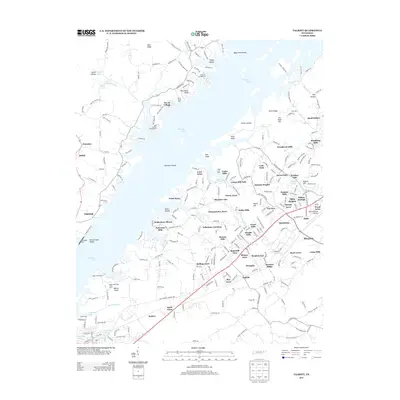
2013 Map of Talbott
USGS Topo · Published 2013About this map
Cherokee Lake dominates the landscape of this East Tennessee region, its irregular shoreline creating a complex geography of points and shoals like Point Seven and Panthers Shoals. This modern topographic survey reveals the dense suburban development extending from Talbott toward the community of Alpha. Numerous residential neighborhoods, including Lakeshore Gardens, Navaho Hills, and Briarcliff View, are established along the ridges and lakefronts, illustrating the area's transition from traditional agricultural land to a commuter landscape.
Find a feature on this map
267 named features on this map. Tap any name to fly to it.
Don’t see what you’re looking for? This feature index may not catch every label — zoom into the map to look around manually.
Map Details
Editions of this 2013 Talbott Map
This is the sole edition of this map. No revisions or reprints were ever made.
Other maps of this area

1883 · Morristown
USGS Topo · 1:125,000

1893 · Morristown
USGS Topo · 1:125,000

1895 · Morristown
USGS Topo · 1:125,000

1897 · Maynardville
USGS Topo · 1:125,000

1900 · Maynardville
USGS Topo · 1:125,000
1935 · White Pine
USGS Topo · 1:24,000
1935 · Tate Springs
USGS Topo · 1:48,000
1935 · Straw Plains
USGS Topo · 1:48,000
1935 · Joppa
USGS Topo · 1:24,000
1935 · Avondale
USGS Topo · 1:24,000