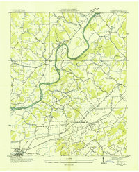
1935 Map of Talbott
USGS Topo · Published 1935About this map
The Holston River winds through a landscape defined by the convergence of Hamblen, Grainger, and Jefferson counties in the mid-1930s. This Tennessee Valley Authority survey captures a rural network of riverfront landmarks and upland farming communities before modern development altered the valley floor. Settlement is clustered around the Southern Railway corridor to the south, where Talbott and the eastern edge of Jefferson City are established. Local life is centered on numerous country institutions like Lebanon Ch, Morgans Sch, and the Martha Sunderland Cem.
Find a feature on this map
76 named features on this map. Tap any name to fly to it.
Don’t see what you’re looking for? This feature index may not catch every label — zoom into the map to look around manually.
Map Details
Editions of this 1935 Talbott Map
This is the sole edition of this map. No revisions or reprints were ever made.
Other maps of this area

1883 · Morristown
USGS Topo · 1:125,000

1893 · Morristown
USGS Topo · 1:125,000

1895 · Morristown
USGS Topo · 1:125,000

1897 · Maynardville
USGS Topo · 1:125,000

1900 · Maynardville
USGS Topo · 1:125,000

1935 · White Pine
USGS Topo · 1:24,000

1935 · Tate Springs
USGS Topo · 1:48,000

1935 · Straw Plains
USGS Topo · 1:48,000

1935 · Joppa
USGS Topo · 1:24,000

1935 · Avondale
USGS Topo · 1:24,000