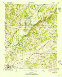
1938 Map of Talbott
USGS Topo · Published 1954About this map
The Holston River carves a dramatic path through this 1938 survey, defining the boundaries between Grainger, Hamblen, and Jefferson Counties. This pre-war landscape is defined by its riparian economy and early transportation networks, notably the Southern railroad and the Johnson Andrew Highway which connect the community of Talbott to Jefferson City. The river features notable landmarks of local history, including Colison Ford and agricultural sites like Old Hull Mill and Lawrence Mill.
Find a feature on this map
60 named features on this map. Tap any name to fly to it.
Don’t see what you’re looking for? This feature index may not catch every label — zoom into the map to look around manually.
Map Details
Editions of this 1938 Talbott Map
This is the sole edition of this map. No revisions or reprints were ever made.
Other maps of this area

1883 · Morristown
USGS Topo · 1:125,000

1893 · Morristown
USGS Topo · 1:125,000

1895 · Morristown
USGS Topo · 1:125,000

1897 · Maynardville
USGS Topo · 1:125,000

1900 · Maynardville
USGS Topo · 1:125,000

1935 · White Pine
USGS Topo · 1:24,000

1935 · Tate Springs
USGS Topo · 1:48,000

1935 · Straw Plains
USGS Topo · 1:48,000

1935 · Joppa
USGS Topo · 1:24,000

1935 · Avondale
USGS Topo · 1:24,000