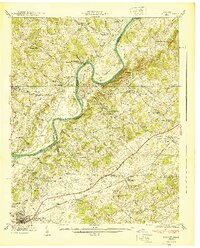
1940 Map of Talbott
USGS Topo · Published 1940About this map
The Holston River winds through this landscape in dramatic oxbows, most notably at Big Horseshoe Bend and Horseshoe Bend. This 1940 topographic study, prepared by the Tennessee Valley Authority, captures the rural character of East Tennessee just before major post-war changes. The agricultural and industrial life of the era is evidenced by several water-powered sites such as Panther Creek Mill, Lawrence Mill, and the colorfully named Old Hell Mill located along the riverbanks near Tarr Island.
Find a feature on this map
57 named features on this map. Tap any name to fly to it.
Don’t see what you’re looking for? This feature index may not catch every label — zoom into the map to look around manually.
Map Details
Editions of this 1940 Talbott Map
This is the sole edition of this map. No revisions or reprints were ever made.
Other maps of this area

1883 · Morristown
USGS Topo · 1:125,000

1893 · Morristown
USGS Topo · 1:125,000

1895 · Morristown
USGS Topo · 1:125,000

1897 · Maynardville
USGS Topo · 1:125,000

1900 · Maynardville
USGS Topo · 1:125,000

1935 · White Pine
USGS Topo · 1:24,000

1935 · Tate Springs
USGS Topo · 1:48,000

1935 · Straw Plains
USGS Topo · 1:48,000

1935 · Joppa
USGS Topo · 1:24,000

1935 · Avondale
USGS Topo · 1:24,000