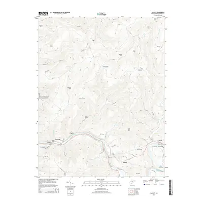
2014 Map of Talcott
USGS Topo · Published 2014About this map
The Greenbrier River carves a dramatic oxbow at Big Bend in this 2014 survey of Summers County. This specific geography necessitated the construction of the Big Bend Tunnels and the Little Bend Tunnel, engineering feats central to local history and folklore. Along the river banks, the settlements of Talcott, Hilldale, and Wiggins are connected by rural routes such as WV-3 and the historic Talcott Bridge. To the north, the landscape rises into high ridges and knobs, including Keeney Mtn and Bald Knob, where smaller communities like Hix and Crossroads are situated. The western edge of the map includes a portion of the New River Gorge National River, highlighting the area's significance as a protected river corridor. Genealogists may find interest in the Greenbrier Cem and family-named features like Sawyer Hollow and Browning Br.
Find a feature on this map
80 named features on this map. Tap any name to fly to it.
Don’t see what you’re looking for? This feature index may not catch every label — zoom into the map to look around manually.
Map Details
Editions of this 2014 Talcott Map
This is the sole edition of this map. No revisions or reprints were ever made.
Other maps of this area

1887 · Hinton
USGS Topo · 1:125,000

1892 · Hinton
USGS Topo · 1:125,000

1912 · Meadow Creek
USGS Topo · 1:48,000

1912 · Big Bend
USGS Topo · 1:62,500

1914 · Big Bend
USGS Topo · 1:62,500

1915 · Meadow Creek
USGS Topo · 1:62,500

1921 · Alderson
USGS Topo · 1:48,000

1921 · Clintonville
USGS Topo · 1:48,000

1923 · Clintonville
USGS Topo · 1:62,500
1923 · Alderson
USGS Topo · 1:62,500