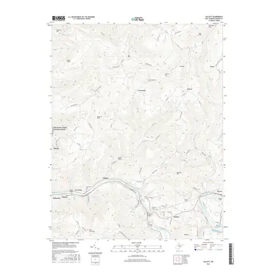
2016 Map of Talcott
USGS Topo · Published 2016About this map
The Greenbrier River dictates the settlement patterns and infrastructure of this Summers County landscape, winding past Hinton and Bellepoint before carving a deep oxbow near Big Bend. This geological bottleneck necessitated significant engineering feats, including the Big Bend Tunnels and the Little Bend Tunnel, which allowed transport to pierce through Big Bend Mtn rather than follow the water's long arc.
Find a feature on this map
89 named features on this map. Tap any name to fly to it.
Don’t see what you’re looking for? This feature index may not catch every label — zoom into the map to look around manually.
Map Details
Editions of this 2016 Talcott Map
This is the sole edition of this map. No revisions or reprints were ever made.
Other maps of this area

1887 · Hinton
USGS Topo · 1:125,000

1892 · Hinton
USGS Topo · 1:125,000

1912 · Meadow Creek
USGS Topo · 1:48,000

1912 · Big Bend
USGS Topo · 1:62,500

1914 · Big Bend
USGS Topo · 1:62,500

1915 · Meadow Creek
USGS Topo · 1:62,500

1921 · Alderson
USGS Topo · 1:48,000

1921 · Clintonville
USGS Topo · 1:48,000

1923 · Clintonville
USGS Topo · 1:62,500
1923 · Alderson
USGS Topo · 1:62,500