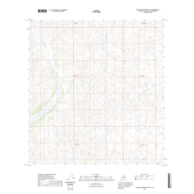
2023 Map of Talkeetna Mountains A-3 SE
USGS Topo · Published 2023About this map
Chickaloon River dominates the western portion of this drainage basin, winding through the high-elevation terrain of the Matanuska-Susitna Borough. The landscape is defined by its complex hydrography, where the headwaters and tributaries of several major systems converge. In the eastern reaches, the Oshetna River and Caribou Creek create a distinct network of valleys, while smaller drainages like Glass Creek and Boulder Creek feed into the primary waterways. This 2023 survey illustrates a wilderness primarily organized by the Public Land Survey System, as evidenced by the township and range lines of t23n r7e and t24n r8e, marking out an area devoid of modern infrastructure or established settlements. The topographic data reveals a land shaped almost entirely by natural flow and elevation, rather than human development.
Find a feature on this map
11 named features on this map. Tap any name to fly to it.
Don’t see what you’re looking for? This feature index may not catch every label — zoom into the map to look around manually.
Map Details
Editions of this 2023 Talkeetna Mountains A-3 SE Map
This is the sole edition of this map. No revisions or reprints were ever made.
Other maps of this area

1948 · Anchorage D-3
USGS Topo · 1:63,360

1948 · Anchorage D-4
USGS Topo · 1:63,360

1950 · Talkeetna Mountains
USGS Topo · 1:250,000

1951 · Anchorage
USGS Topo · 1:250,000

1951 · Talkeetna Mountains A-2
USGS Topo · 1:63,360

1951 · Talkeetna Mountains A-3
USGS Topo · 1:63,360

1952 · Anchorage D-4
USGS Topo · 1:63,360

1952 · Anchorage D-3
USGS Topo · 1:63,360
1952 · Talkeetna Mountains A-2
USGS Topo · 1:63,360
1952 · Talkeetna Mountains A-3
USGS Topo · 1:63,360