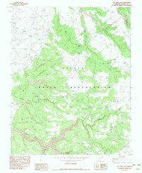
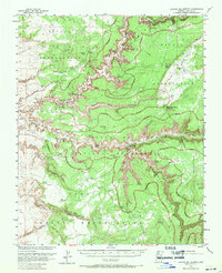
1982 Map of Tall Tree Mesa
USGS Topo · Published 1982About this map
Navajo Indian Reservation lands in Apache County are meticulously detailed in this provisional survey, which documents a complex network of canyons and mesas in the high desert. The landscape is defined by massive formations like Tall Tree Mesa and Black Mesa, dissected by deep drainages including Yellowstone Canyon and Tezinie Canyon. Notable for its focus on topographical nuances, the sheet identifies specific named pockets of the canyon system such as Jimson Weed Canyon and Sheep Dip Canyon. The seasonal water flow of Agua Sal Creek provides the primary drainage through this arid territory. This 1980s-era record also traces modern infrastructure developments, specifically the Steel Tower Trans Line, cutting across the traditional terrain near Owl Nest and Bilasha.
Find a feature on this map
12 named features on this map. Tap any name to fly to it.
Don’t see what you’re looking for? This feature index may not catch every label — zoom into the map to look around manually.
Map Details
Editions of this 1982 Tall Tree Mesa Map
This is the sole edition of this map. No revisions or reprints were ever made.
Other maps of this area

1892 · Canyon De Chelly
USGS Topo · 1:250,000

1954 · Shiprock
USGS Topo · 1:250,000

1955 · Chinle 4 NE
USGS Topo · 1:24,000

1955 · Sonsala Butte 2 SW
USGS Topo · 1:24,000

1955 · Sonsala Butte 2 NW
USGS Topo · 1:24,000

1955 · Sonsala Butte 2 SE
USGS Topo · 1:24,000
1955 · Sonsala Butte 3 NE
USGS Topo · 1:24,000
1955 · Sonsala Butte 2 NE
USGS Topo · 1:24,000
1955 · Sonsala Butte 3 NW
USGS Topo · 1:24,000
1955 · Canyon Del Muerto
USGS Topo · 1:62,500