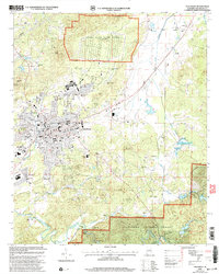
2001 Map of Talladega
USGS Topo · Published 2004About this map
Talladega and its surrounding landscape are captured here at the turn of the twenty-first century, revealing a city defined by its longstanding educational and military footprint. To the northwest, the massive Coosa River Depot Annex occupies a significant portion of the terrain, while the historic grounds of Talladega College and the specialized Helen Keller Sch of Ala highlight the community's role as a regional center for education. The map illustrates the southern expansion of the city toward Bemiston and the transition into the dense woodland of the Talladega National Forest.
Find a feature on this map
47 named features on this map. Tap any name to fly to it.
Don’t see what you’re looking for? This feature index may not catch every label — zoom into the map to look around manually.
Map Details
Editions of this 2001 Talladega Map
This is the sole edition of this map. No revisions or reprints were ever made.
Other maps of this area

1889 · Springville
USGS Topo · 1:125,000

1890 · Talladega
USGS Topo · 1:125,000

1891 · Ashland
USGS Topo · 1:125,000

1892 · Springville
USGS Topo · 1:125,000

1892 · Talladega
USGS Topo · 1:125,000

1900 · Anniston
USGS Topo · 1:125,000

1943 · Talladega
USGS Topo · 1:62,500

1946 · Talladega
USGS Topo · 1:62,500

1947 · Eastaboga
USGS Topo · 1:24,000

1947 · Ragland
USGS Topo · 1:62,500