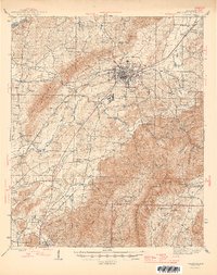
1946 Map of Talladega
USGS Topo · Published 1946About this map
Talladega serves as the industrial and civic anchor of this mid-century landscape, where the Southern RR, Louisville and Nashville RR, and the Atlanta Birmingham and Coastal RR converge. This rail network supports textile manufacturing at Bemiston and local milling operations like Allison Mills and Reynolds Mill. The terrain is defined by the steep rises of the Giants Stairway and Talladega Mountain, the latter protected within the Talladega National Forest.
Find a feature on this map
87 named features on this map. Tap any name to fly to it.
Don’t see what you’re looking for? This feature index may not catch every label — zoom into the map to look around manually.
Map Details
Editions of this 1946 Talladega Map
2 editions found

Other maps of this area

1889 · Springville
USGS Topo · 1:125,000

1890 · Talladega
USGS Topo · 1:125,000

1891 · Ashland
USGS Topo · 1:125,000

1892 · Springville
USGS Topo · 1:125,000

1892 · Talladega
USGS Topo · 1:125,000

1900 · Anniston
USGS Topo · 1:125,000

1915 · Gantts Quarry
USGS Topo · 1:48,000

1917 · Gantts Quarry
USGS Topo · 1:62,500

1943 · Talladega
USGS Topo · 1:62,500

1944 · Goodwater
USGS Topo · 1:62,500