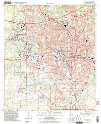
1999 Map of Tallahassee
USGS Topo · Published 2000About this map
Florida State University and Florida A&M University anchor the urban core of Florida's capital, where the city's academic and political life meets the northern edge of the Apalachicola National Forest. The landscape is defined by its numerous lakes and swamps, including Lake Bradford and the Black Swamp, which separate the developed city center from the Tallahassee Regional Airport. Notable local history is preserved in the Old City Cem and Oakland Cemetery, while the northern hills transition toward Indian Mounds State Park. Transport corridors like the CSX Transportation rail line and Tennessee St trace the growth of the state capital as it expanded toward suburban reaches like Belair and Lakeside. The concentration of numerous primary and secondary schools, from Leon High Sch to Springwood Elementary Sch, illustrates the dense residential planning of the late 20th century.
Find a feature on this map
100 named features on this map. Tap any name to fly to it.
Don’t see what you’re looking for? This feature index may not catch every label — zoom into the map to look around manually.
Map Details
Editions of this 1999 Tallahassee Map
This is the sole edition of this map. No revisions or reprints were ever made.
Other maps of this area

1940 · Tallahassee
USGS Topo · 1:62,500

1942 · Tallahassee
USGS Topo · 1:62,500

1943 · Tallahassee
USGS Topo · 1:62,500

1954 · Lafayette
USGS Topo · 1:24,000

1954 · Woodville
USGS Topo · 1:24,000

1954 · Tallahassee
USGS Topo · 1:250,000

1959 · Tallahassee
USGS Topo · 1:250,000

1960 · Tallahassee
USGS Topo · 1:250,000
1963 · Bradfordville
USGS Topo · 1:24,000

1963 · Lake Jackson
USGS Topo · 1:24,000