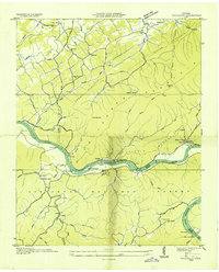
1935 Map of Tallassee
USGS Topo · Published 1935About this map
Little Tennessee River winds through the heart of this 1935 survey, a period when ferries still served as vital crossings before the large-scale impoundments of the Tennessee Valley Authority altered the valley. The landscape is defined by the steep slopes of Chilhowee Mountain and Short Mountain, with settlement concentrated along the fertile banks and creek bottoms. This map captures the social fabric of rural Blount and Monroe counties through its numerous country schools like Nelson Sch and Kagley Sch, and spiritual centers such as McMurray Chapel and the Lower Chilhowee Ch.
Find a feature on this map
68 named features on this map. Tap any name to fly to it.
Don’t see what you’re looking for? This feature index may not catch every label — zoom into the map to look around manually.
Map Details
Editions of this 1935 Tallassee Map
This is the sole edition of this map. No revisions or reprints were ever made.
Other maps of this area

1886 · Knoxville
USGS Topo · 1:125,000

1892 · Knoxville
USGS Topo · 1:125,000

1893 · Murphy
USGS Topo · 1:125,000

1894 · Knoxville
USGS Topo · 1:125,000

1895 · Loudon
USGS Topo · 1:125,000

1895 · Knoxville
USGS Topo · 1:125,000

1901 · Knoxville
USGS Topo · 1:125,000

1914 · Murphy
USGS Topo · 1:125,000

1933 · Haw Knob
USGS Topo · 1:48,000

1933 · Whiteoak Flats
USGS Topo · 1:24,000