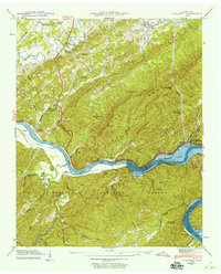
1941 Map of Tallassee
USGS Topo · Published 1959About this map
Chilhowee Lake dominates the center of this 1941 landscape, reflecting a time of significant transition for the Little Tennessee River valley along the Blount and Monroe county line. The map records the early footprints of the Tennessee Valley Authority’s impact, noting areas submerged by the lake's rising waters. Historic river crossings like Tallassee Ferry and Jones Ferry appear alongside riverside settlements such as Lower Chilhowee and Tallassee. To the north, the foothills of Chilhowee Mountain shelter small rural communities like Wellsville and Pumpkin Center. The presence of Great Smoky Mountains National Park and the Cherokee National Forest marks the preservation of the surrounding wilderness. Genealogists can find numerous family-named landmarks and institutions, including the Quaker Cem Happy Top Ch, Kagley Chapel, and Lanier Sch.
Find a feature on this map
60 named features on this map. Tap any name to fly to it.
Don’t see what you’re looking for? This feature index may not catch every label — zoom into the map to look around manually.
Map Details
Editions of this 1941 Tallassee Map
This is the sole edition of this map. No revisions or reprints were ever made.
Other maps of this area

1886 · Knoxville
USGS Topo · 1:125,000

1892 · Knoxville
USGS Topo · 1:125,000

1893 · Murphy
USGS Topo · 1:125,000

1894 · Knoxville
USGS Topo · 1:125,000

1895 · Loudon
USGS Topo · 1:125,000

1895 · Knoxville
USGS Topo · 1:125,000

1901 · Knoxville
USGS Topo · 1:125,000

1914 · Murphy
USGS Topo · 1:125,000

1933 · Haw Knob
USGS Topo · 1:48,000

1933 · Whiteoak Flats
USGS Topo · 1:24,000