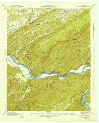
1942 Map of Tallassee
USGS Topo · Published 1942About this map
Little Tennessee River winds through the heart of this 1941 field examination, carving a path between Chilhowee Mountain and the Cherokee National Forest. The landscape is defined by its pre-dam riverine economy, where transit depended on river crossings such as Jones Ferry, Tallassee Ferry, and Scona Lodge Ferry. Small agrarian communities like Tallassee and Wellsville are documented alongside numerous family and community landmarks, including Quaker Cem, Williamson Chapel, and Lanier Sch. To the south, Citico Creek feeds into the main river near Citico Beach, while the eastern edge of the map touches the boundary of Great Smoky Mts Nat Park. The mapping captures the distinct topography of gaps and leads, such as Stony Grave Gap and Cockspur Lead, before modern hydroelectric projects significantly altered the flow and shoreline of the Little Tennessee.
Find a feature on this map
56 named features on this map. Tap any name to fly to it.
Don’t see what you’re looking for? This feature index may not catch every label — zoom into the map to look around manually.
Map Details
Editions of this 1942 Tallassee Map
This is the sole edition of this map. No revisions or reprints were ever made.
Other maps of this area

1886 · Knoxville
USGS Topo · 1:125,000

1892 · Knoxville
USGS Topo · 1:125,000

1893 · Murphy
USGS Topo · 1:125,000

1894 · Knoxville
USGS Topo · 1:125,000

1895 · Loudon
USGS Topo · 1:125,000

1895 · Knoxville
USGS Topo · 1:125,000

1901 · Knoxville
USGS Topo · 1:125,000

1914 · Murphy
USGS Topo · 1:125,000

1933 · Haw Knob
USGS Topo · 1:48,000

1933 · Whiteoak Flats
USGS Topo · 1:24,000