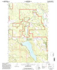
1994 Map of Tally Lake
USGS Topo · Published 1997About this map
The Stillwater River winds through the northeastern corner of this Montana landscape, where the Burlington Northern railroad corridor meets the settlement of Lupfer. This area within the Flathead National Forest is defined by its dramatic transition from river valley to the heights of Tally Mountain. Centered around the expansive Tally Lake, the map details a region managed for both timber and recreation, featuring a Fishing Access point and a Water Tank near the western shore. High-elevation basins such as Round Meadow and Long Meadow dot the terrain, while the Round Meadow Cross Country Ski Area highlights the seasonal use of these forest lands. Numerous drainage systems including Good Creek, Logan Creek, and Toble Creek feed into the central lake and river systems, illustrating the complex hydrology of the Salish Mountains.
Find a feature on this map
26 named features on this map. Tap any name to fly to it.
Don’t see what you’re looking for? This feature index may not catch every label — zoom into the map to look around manually.
Map Details
Editions of this 1994 Tally Lake Map
2 editions found
Other maps of this area

1906 · Kintla Lakes
USGS Topo · 1:125,000

1913 · Stryker
USGS Topo · 1:125,000

1916 · Stryker
USGS Topo · 1:125,000

1938 · Kintla Lakes
USGS Topo · 1:125,000

1943 · Kalispell
USGS Topo · 1:125,000

1957 · Kalispell
USGS Topo · 1:250,000

1960 · Kalispell
USGS Topo · 1:250,000

1961 · Kalispell
USGS Topo · 1:250,000

1962 · Johnson Peak
USGS Topo · 1:24,000

1962 · Beaver Lake
USGS Topo · 1:24,000