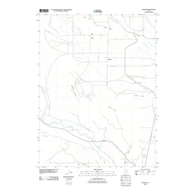
2010 Map of Talmage
USGS Topo · Published 2010About this map
Talmage and Utahn serve as the primary focal points of this northeastern Utah landscape, situated in an area defined by sophisticated irrigation and diverse topographical benches. The Duchesne River winds through the southern section of the quadrangle, flanked by the Pioneer Canal and Knight Ditch, which demonstrate the importance of water management to the local settlements. Notable family and historical landmarks include the Talmage Cemetery and Utahn Cemetery, providing valuable points of reference for genealogists. The terrain rises and falls from the heights of Steamboat Mountain to the broad expanses of Blue Bench, Hair Bench, and West Bench. North of the river, the settlement pattern is shaped by geographic features like Draper Hollow and Todd Hill, while transportation is facilitated by routes such as Rock Creek Rd.
Find a feature on this map
23 named features on this map. Tap any name to fly to it.
Don’t see what you’re looking for? This feature index may not catch every label — zoom into the map to look around manually.
Map Details
Editions of this 2010 Talmage Map
This is the sole edition of this map. No revisions or reprints were ever made.
Other maps of this area

1885 · Uinta
USGS Topo · 1:250,000

1939 · Duchesne
USGS Topo · 1:125,000

1954 · Salt Lake City
USGS Topo · 1:250,000

1958 · Salt Lake City
USGS Topo · 1:250,000

1960 · Salt Lake City
USGS Topo · 1:250,000

1962 · Blacktail Mtn
USGS Topo · 1:24,000

1962 · Rabbit Gulch
USGS Topo · 1:24,000

1962 · Dry Mountain
USGS Topo · 1:24,000
1964 · Duchesne NE
USGS Topo · 1:24,000
1965 · Mountain Home
USGS Topo · 1:24,000