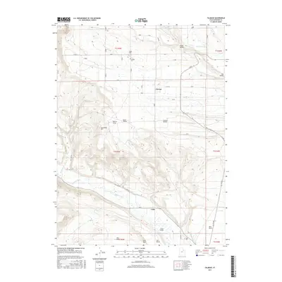
2017 Map of Talmage
USGS Topo · Published 2017About this map
Talmage and Utahn anchor this Duchesne County landscape, showing the organized agricultural and irrigation patterns of the Uinta Valley. The settlement at Talmage is centered near the Talmage Cem, while Utahn sits further south along the Duchesne River corridor. The map reveals the critical importance of water management in this arid region, featuring an extensive network of man-made waterways like the Pioneer Canal, Lateral Number 3, and Knight Ditch that draw from Pigeon Water Cr and other natural streams.
Find a feature on this map
40 named features on this map. Tap any name to fly to it.
Don’t see what you’re looking for? This feature index may not catch every label — zoom into the map to look around manually.
Map Details
Editions of this 2017 Talmage Map
This is the sole edition of this map. No revisions or reprints were ever made.
Other maps of this area

1885 · Uinta
USGS Topo · 1:250,000

1939 · Duchesne
USGS Topo · 1:125,000

1954 · Salt Lake City
USGS Topo · 1:250,000

1958 · Salt Lake City
USGS Topo · 1:250,000

1960 · Salt Lake City
USGS Topo · 1:250,000

1962 · Blacktail Mtn
USGS Topo · 1:24,000

1962 · Rabbit Gulch
USGS Topo · 1:24,000

1962 · Dry Mountain
USGS Topo · 1:24,000
1964 · Duchesne NE
USGS Topo · 1:24,000
1965 · Mountain Home
USGS Topo · 1:24,000