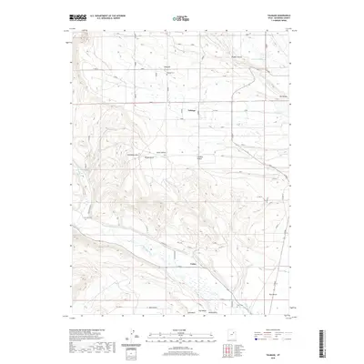
2020 Map of Talmage
USGS Topo · Published 2020About this map
Talmage and the nearby settlement of Utahn occupy a transition between the elevated northern terrain and the fertile Uinta Valley floor. The region is defined by an intricate network of irrigation, featuring the Pioneer Canal, Knight Ditch, and Lateral Number 3, which direct water from the Duchesne River and Pigeon Water Cr to support local agriculture. This reliance on water management is a hallmark of the landscape, where the flat expanses of Blue Bench and West Bench contrast with the prominent rise of Steamboat Mtn.
Find a feature on this map
35 named features on this map. Tap any name to fly to it.
Don’t see what you’re looking for? This feature index may not catch every label — zoom into the map to look around manually.
Map Details
Editions of this 2020 Talmage Map
This is the sole edition of this map. No revisions or reprints were ever made.
Other maps of this area

1885 · Uinta
USGS Topo · 1:250,000

1939 · Duchesne
USGS Topo · 1:125,000

1954 · Salt Lake City
USGS Topo · 1:250,000

1958 · Salt Lake City
USGS Topo · 1:250,000

1960 · Salt Lake City
USGS Topo · 1:250,000

1962 · Blacktail Mtn
USGS Topo · 1:24,000

1962 · Rabbit Gulch
USGS Topo · 1:24,000

1962 · Dry Mountain
USGS Topo · 1:24,000
1964 · Duchesne NE
USGS Topo · 1:24,000
1965 · Mountain Home
USGS Topo · 1:24,000