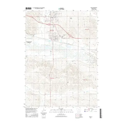
2015 Map of Tama
USGS Topo · Published 2015About this map
Toledo and Tama anchor this central Iowa landscape, positioned just north of the wide valley where the Iowa River flows eastward. The map documents the residential and commercial street grids of these adjacent communities, including several local landmarks such as the Lincoln Highway Bridge and Cherry Lake. West of the primary settlements, the Mesquakie Indian Settlement occupies a significant portion of the river valley, illustrating the enduring cultural geography of the region. The surrounding agricultural uplands are dissected by numerous waterways including Richland Cr and Deer Cr. For genealogists and local historians, the sheet provides precise locations for several regional burial grounds, including Woodlawn Cem and the Saint Patricks Cem. This 2015 survey reflects a landscape where modern infrastructure like the Toledo Municipal Airport and Tama Airport coexists with the established rural road network of the Iowa interior.
Find a feature on this map
67 named features on this map. Tap any name to fly to it.
Don’t see what you’re looking for? This feature index may not catch every label — zoom into the map to look around manually.
Map Details
Editions of this 2015 Tama Map
This is the sole edition of this map. No revisions or reprints were ever made.
Other maps of this area

1954 · Waterloo
USGS Topo · 1:250,000

1954 · Des Moines
USGS Topo · 1:250,000

1955 · Waterloo
USGS Topo · 1:250,000

1956 · Des Moines
USGS Topo · 1:250,000

1957 · Des Moines
USGS Topo · 1:250,000

1968 · Belle Plaine SW
USGS Topo · 1:24,000

1968 · Chelsea
USGS Topo · 1:24,000

1969 · Des Moines
USGS Topo · 1:250,000
1971 · Clutier
USGS Topo · 1:24,000

1971 · Garwin
USGS Topo · 1:24,000