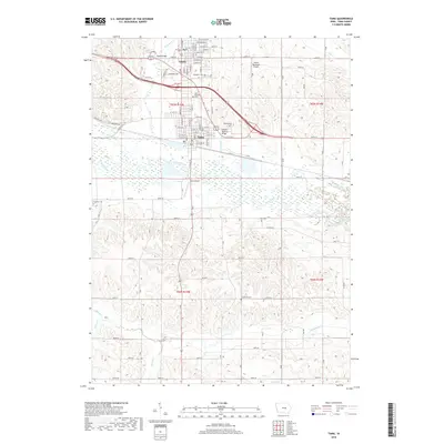
2018 Map of Tama
USGS Topo · Published 2018About this map
The Iowa River corridor defines the landscape between the twin communities of Toledo and Tama in this modern-era survey. The settlement pattern reveals two distinct urban grids separated by the river's broad floodplain and the infrastructure of the Tama Airport. Several significant crossings are documented, including the Toledo Bridge and the Lincoln Highway Bridge, the latter reflecting the area's place along one of the country's most significant early transcontinental routes. Beyond the municipal centers, the landscape is heavily marked by rural history, particularly visible through a network of local burial grounds such as Woodlawn Cem, Saint Patricks Cem, and Oakhill Cem. The surrounding hills are drained by numerous waterways including Richland Cr and Deer Cr, which feed into the primary river valley that remains the central geographic feature of the region.
Find a feature on this map
26 named features on this map. Tap any name to fly to it.
Don’t see what you’re looking for? This feature index may not catch every label — zoom into the map to look around manually.
Map Details
Editions of this 2018 Tama Map
This is the sole edition of this map. No revisions or reprints were ever made.
Other maps of this area

1954 · Waterloo
USGS Topo · 1:250,000

1954 · Des Moines
USGS Topo · 1:250,000

1955 · Waterloo
USGS Topo · 1:250,000

1956 · Des Moines
USGS Topo · 1:250,000

1957 · Des Moines
USGS Topo · 1:250,000

1968 · Belle Plaine SW
USGS Topo · 1:24,000

1968 · Chelsea
USGS Topo · 1:24,000

1969 · Des Moines
USGS Topo · 1:250,000
1971 · Clutier
USGS Topo · 1:24,000

1971 · Garwin
USGS Topo · 1:24,000