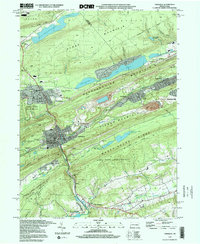
1997 Map of Tamaqua
USGS Topo · Published 2000About this map
Tamaqua sits at the heart of this late-1990s industrial landscape, where the Little Schuylkill River cuts through a succession of ridges including Sharp Mountain and Pisgah Mountain. The area’s coal mining legacy is evident in the Strip Mine operations and the sprawling Arlington Yards, while the Conrail line follows the valley floor to serve the borough's tight-knit neighborhoods. Community life is anchored by landmarks like Zion Ch, St Jeromes Ch, and the Tamaqua Area High Sch.
Find a feature on this map
67 named features on this map. Tap any name to fly to it.
Don’t see what you’re looking for? This feature index may not catch every label — zoom into the map to look around manually.
Map Details
Editions of this 1997 Tamaqua Map
This is the sole edition of this map. No revisions or reprints were ever made.
Other maps of this area

1889 · Hazleton
USGS Topo · 1:62,500

1889 · Pottsville
USGS Topo · 1:62,500

1891 · Hazleton
USGS Topo · 1:62,500

1891 · Pottsville
USGS Topo · 1:62,500

1892 · Mahanoy
USGS Topo · 1:62,500

1893 · Hazleton
USGS Topo · 1:62,500

1893 · Mahanoy
USGS Topo · 1:62,500

1909 · Hamburg
USGS Topo · 1:62,500

1911 · Hamburg
USGS Topo · 1:62,500

1944 · Orwigsburg
USGS Topo · 1:24,000