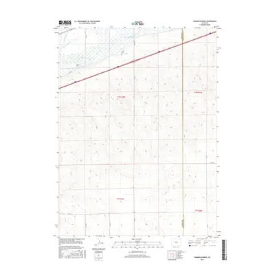
2016 Map of Tamarack Ranch
USGS Topo · Published 2016About this map
The South Platte River corridor dominates this high-plains landscape, carving through the northern edge of the terrain where Logan and Sedgwick counties meet. Near the riverbanks, an intricate system of irrigation channels including Settlers Ditch and Long Island Ditch reflects the area's essential agricultural history and the redirection of water for ranching. Tamarack Ranch stands as a primary landmark in this region, positioned within a landscape defined by expansive township and range grids. The terrain is marked by a network of rural routes such as Red Lion Rd and several numbered county roads that provide access across the arid slopes. These transit lines, alongside the prominent path of Interstate 76, demonstrate how transportation and water management have shaped human presence in this corner of Colorado.
Find a feature on this map
20 named features on this map. Tap any name to fly to it.
Don’t see what you’re looking for? This feature index may not catch every label — zoom into the map to look around manually.
Map Details
Editions of this 2016 Tamarack Ranch Map
This is the sole edition of this map. No revisions or reprints were ever made.
Other maps of this area
1952 · Marks Butte
USGS Topo · 1:24,000
1953 · Tamarack Ranch
USGS Topo · 1:24,000
1953 · Crook
USGS Topo · 1:24,000
1953 · Twin Buttes
USGS Topo · 1:24,000
1953 · Julesburg Reservoir
USGS Topo · 1:24,000
1953 · Sedgwick
USGS Topo · 1:24,000
1954 · Sterling
USGS Topo · 1:250,000
1958 · Sterling
USGS Topo · 1:250,000
1962 · Fleming
USGS Topo · 1:24,000
1962 · Haxtun East
USGS Topo · 1:24,000