
1962 Map of Haxtun East
USGS Topo · Published 1964About this map
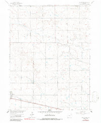
Haxtun sits at the southwestern edge of this survey, anchored by the Chicago Burlington and Quincy railroad line that cuts across the prairie landscape. The terrain is defined by the ephemeral drainage of Wildhorse Creek, which wanders through the northern and eastern sections of the quadrangle. This area, spanning the Sedgwick and Phillips County line, reflects a mid-century agricultural environment where small-scale industrial markers like a Borrow Pit and the local Sewage Disposal facility are noted near the town center. For those researching local family history, the Fairfield Cem is a significant landmark situated in the northeastern portion of the map, serving the surrounding rural sections. The detailed topography, mapped during the early 1960s, captures the high plains character of the region before modern expansion altered the footprint of these farming communities.
Find a feature on this map
7 named features on this map. Tap any name to fly to it.
Don’t see what you’re looking for? This feature index may not catch every label — zoom into the map to look around manually.
Map Details
Editions of this 1962 Haxtun East Map
2 editions found
Other maps of this area

1952 · Julesburg SW
USGS Topo · 1:24,000

1952 · Marks Butte
USGS Topo · 1:24,000

1953 · Tamarack Ranch
USGS Topo · 1:24,000

1954 · Sterling
USGS Topo · 1:250,000

1958 · Sterling
USGS Topo · 1:250,000

1962 · Haxtun West
USGS Topo · 1:24,000

1962 · Holyoke NW
USGS Topo · 1:24,000

1971 · Paoli
USGS Topo · 1:24,000

1971 · Haxtun SE
USGS Topo · 1:24,000

1972 · Rockland
USGS Topo · 1:24,000