
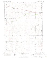
1971 Map of Paoli
USGS Topo · Published 1973About this map
Paoli sits at the heart of this agricultural landscape in Phillips County, serving as a primary rail point during the early 1970s. The settlement's connection to the wider region is defined by the Burlington Northern railroad, which cuts a straight line across the plains. Local history is anchored at the Posegate Cem, located west of the town center near the confluence of the North Fork Frenchman Creek and South Fork Frenchman Creek. The terrain is defined by the drainage patterns of these forks and Sandy Creek, illustrating the importance of water management in this high plains environment. Scattered well sites across the map indicate the transition to more intensive irrigation practices common in eastern Colorado during this period.
Find a feature on this map
8 named features on this map. Tap any name to fly to it.
Don’t see what you’re looking for? This feature index may not catch every label — zoom into the map to look around manually.
Map Details
Editions of this 1971 Paoli Map
2 editions found
Other maps of this area

1954 · Sterling
USGS Topo · 1:250,000

1958 · Sterling
USGS Topo · 1:250,000

1962 · Holyoke NE
USGS Topo · 1:24,000

1962 · Haxtun East
USGS Topo · 1:24,000

1962 · Holyoke NW
USGS Topo · 1:24,000

1971 · Holyoke
USGS Topo · 1:24,000

1971 · Fiddler Peak
USGS Topo · 1:24,000

1971 · Wauneta NE
USGS Topo · 1:24,000

1971 · Clarkville NE
USGS Topo · 1:24,000

1971 · Haxtun SE
USGS Topo · 1:24,000