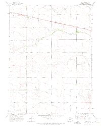
1971 Map of Paoli
USGS Topo · Published 1973About this map
Paoli sits at the intersection of prairie commerce and rail transit in this high plains landscape. The Burlington Northern railroad cuts a straight diagonal across the northern township, providing a vital link for the agricultural community. Water drainage is defined by the confluence of the North Fork Frenchman Creek and the South Fork Frenchman Creek, which merge to form the main stem of Frenchman Creek. These intermittent waterways, along with Sandy Creek to the south, carve subtle relief into the terrain.
Find a feature on this map
8 named features on this map. Tap any name to fly to it.
Don’t see what you’re looking for? This feature index may not catch every label — zoom into the map to look around manually.
Map Details
Editions of this 1971 Paoli Map
2 editions found
Other maps of this area

1954 · Sterling
USGS Topo · 1:250,000

1958 · Sterling
USGS Topo · 1:250,000

1962 · Holyoke NE
USGS Topo · 1:24,000

1962 · Haxtun East
USGS Topo · 1:24,000

1962 · Holyoke NW
USGS Topo · 1:24,000

1971 · Paoli
USGS Topo · 1:24,000

1971 · Holyoke
USGS Topo · 1:24,000

1971 · Fiddler Peak
USGS Topo · 1:24,000

1971 · Wauneta NE
USGS Topo · 1:24,000

1971 · Clarkville NE
USGS Topo · 1:24,000