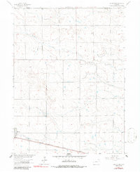
1962 Map of Haxtun East
USGS Topo · Published 1986About this map
Wildhorse Creek meanders through the high plains of Northeast Colorado, carving a distinct drainage pattern across the landscape of Phillips County and Sedgwick County. The town of Haxtun serves as the primary regional hub, situated along the vital transport corridor of the Chicago Burlington and Quincy railroad. This line, cutting diagonally across the southern portion of the quadrangle, was essential for moving agricultural goods from this prairie region. Local life and history are anchored by landmarks like the Fairfield Cem and early utility infrastructure such as the Sewage Disposal facility. The map captures a transition in land use, where natural draws and creek beds contrast with the rigid township and range grid that organized settlement and farming throughout the mid-20th century.
Find a feature on this map
7 named features on this map. Tap any name to fly to it.
Don’t see what you’re looking for? This feature index may not catch every label — zoom into the map to look around manually.
Map Details
Editions of this 1962 Haxtun East Map
2 editions found
Other maps of this area

1952 · Julesburg SW
USGS Topo · 1:24,000

1952 · Marks Butte
USGS Topo · 1:24,000

1953 · Tamarack Ranch
USGS Topo · 1:24,000

1954 · Sterling
USGS Topo · 1:250,000

1958 · Sterling
USGS Topo · 1:250,000

1962 · Haxtun East
USGS Topo · 1:24,000

1962 · Haxtun West
USGS Topo · 1:24,000

1962 · Holyoke NW
USGS Topo · 1:24,000

1971 · Paoli
USGS Topo · 1:24,000

1971 · Haxtun SE
USGS Topo · 1:24,000