
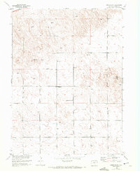
1952 Map of Marks Butte
USGS Topo · Published 1954About this map
Price Ranch and a landscape dotted with numerous windmills characterize this 1950s survey of the High Plains near the Colorado border. The map documents a sparsely populated ranching region where water security was clearly paramount, as evidenced by the high density of windmill labels across the sections. The presence of the Sunrise School (Aband) indicates a shift in local educational patterns, showing where a rural community once gathered before the school was vacated. Elevated landmarks like Marks Butte and the geodetic marker at VABM 4093 Sedgwick provide topographical context for this corner of Sedgwick County. A lone Gravel Pit near the center of the sheet points to local infrastructure needs and small-scale resource extraction during the early postwar era.
Find a feature on this map
7 named features on this map. Tap any name to fly to it.
Don’t see what you’re looking for? This feature index may not catch every label — zoom into the map to look around manually.
Map Details
Editions of this 1952 Marks Butte Map
2 editions found
Other maps of this area

1952 · Julesburg SW
USGS Topo · 1:24,000

1953 · Ovid
USGS Topo · 1:24,000

1953 · Tamarack Ranch
USGS Topo · 1:24,000

1953 · Julesburg Reservoir
USGS Topo · 1:24,000

1953 · Sedgwick
USGS Topo · 1:24,000

1954 · Sterling
USGS Topo · 1:250,000

1958 · Sterling
USGS Topo · 1:250,000

1962 · Haxtun East
USGS Topo · 1:24,000

1962 · Haxtun West
USGS Topo · 1:24,000

1962 · Holyoke NW
USGS Topo · 1:24,000